Get HelmStation ->
 powered by MacENC
The next evolution of the venerable mac chart app. Now in the App Store with seamless in-app chart subscriptions.
More devices then ever before:
- Supported on any mac you own, up to five active computers.
- No more finicky license management. HelmStation just runs. Your current active in-app chart subscriptions will download and run on them all.
System Requirements:
- Optimized and recommended for Macs that can run macOS 14 (Sonoma) and newer (Apple Compatibility List)
- Upgrades and fixes for Apple Officially Supported macOS versions
Recommended for all Apple Silicon (M*) Macs
- Optimized for Apple Silicon.
- Best performance on macOS Sonoma and newer.
Supports Intel Macs:
- Universal App! Runs on Intel Macs.
- Best experience on Intel Core i7 processor equipped macs (MacBook Pro, Mini, or Air 2018 or newer) running macOS 14 (Sonoma) and newer.
Feature List
In-App chart store. Browse or search for chart subscriptions. Seamless apple pay. Automatic chart management. Powered by our cloud services and partnered with ChartWorld. HelmStation manages your subscription chart content on all devices. View status of your content and progress on updates, provisioning, and installation. Fully automated and seamless. Your HelmStation ChartStore purchases downloaded and ready to use in just minutes.
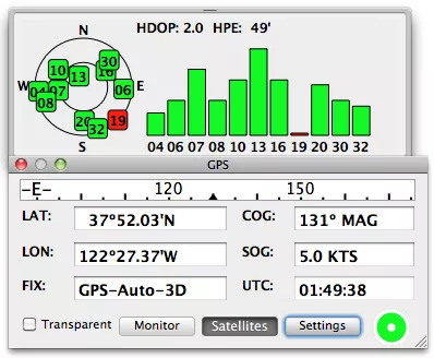
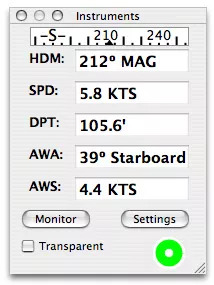
GPS & Instruments – Real time and Simulated display of current LAT/LON (position), SOG (Speed over Ground), COG (Course over Ground), BTW (Bearing to Waypoint), DTW (Distance to Waypoint), VMG (Velocity Made Good), XTE (Cross Track Error), TTG (Time to Go) for waypoint and entire route, a satellite graph and a NMEA monitor. GPS data can be repeated to another device such as control of an Autopilot. Additional instrument data (Heading, Speed, Depth, Temperature, Wind Angle and Windspeed) is also displayed. Having all this information literally at your fingertips, assures that you remain informed of your position and course.
Charting & Plotting – Current position with velocity vector, waypoints, routes and track history are plotted. Seamless quilted vector or raster chart scrolls keeping current position centered. North up or course up orientation. Chart may be displayed with low light viewing intensity. Click on any object on the chart and see complete details. Search and scroll to any object on the chart. Chart can be “marked up” in any color. No more marking, erasing and remarking paper charts… know where you are, where you’ve been, and where you’re going!
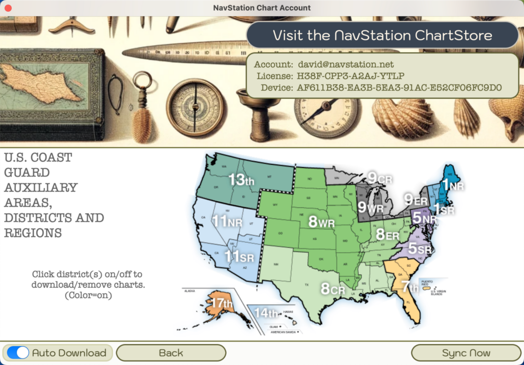
Install any or all ENC S-57 chart catalogs from US NOAA. Value priced chart download service renewable in-app subscription.
Chart sets organized by the 9 US Coast Guard Districts.
Just select your region and HelmStation automatically downloads and installs.
Automated updates always keep you safe with the very latest official charts.
Zooming & Scrolling – Show chart at scales between 1:2,500 and 1:20,000,000 zoom with excellent clarity. Rectangle zoom select to display any part of the chart. Scroll with chart drag or arrow keys. Easy zooming on double click, touchpad scroll, pinch, & zoom gestures, mouse scroll wheel, or select direct zoom level.
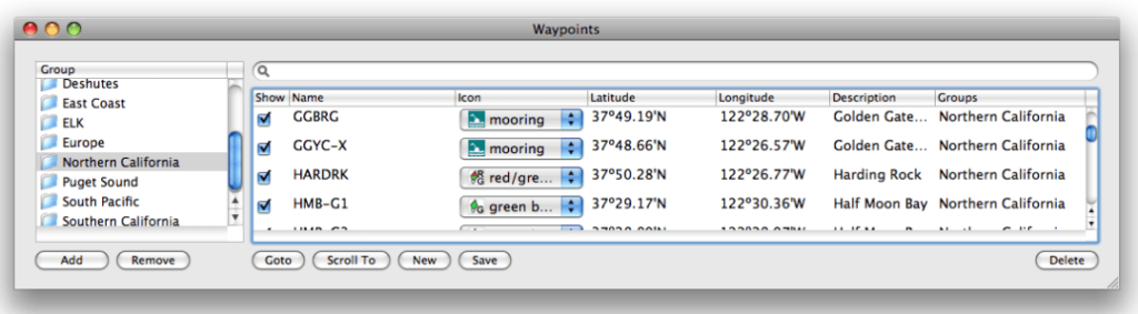
Waypoints – Create, edit, drag and goto. Waypoints include a name, icon, and description. Waypoints can be saved, exported/imported and transferred to/from the GPS. Waypoint positions can be displayed in several user selectable formats. Flexible Waypoint usage makes it extremely easy to set a course for intermediate destinations, or to return to previous ones. Found a great fishing hole or anchorage? No problem… save it to a Waypoint for future reference.
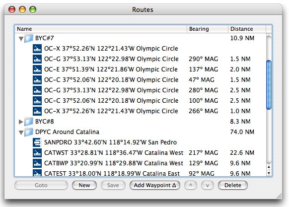
Routes – Create, edit, drag and goto including auto advance. Routes include a name and total distance. For each waypoint in the route the bearing and distance from the previous waypoint is given. Routes can be saved and transferred to/from the GPS. Flexible routing features make it very easy to plan a trip or to repeat a previous trip.
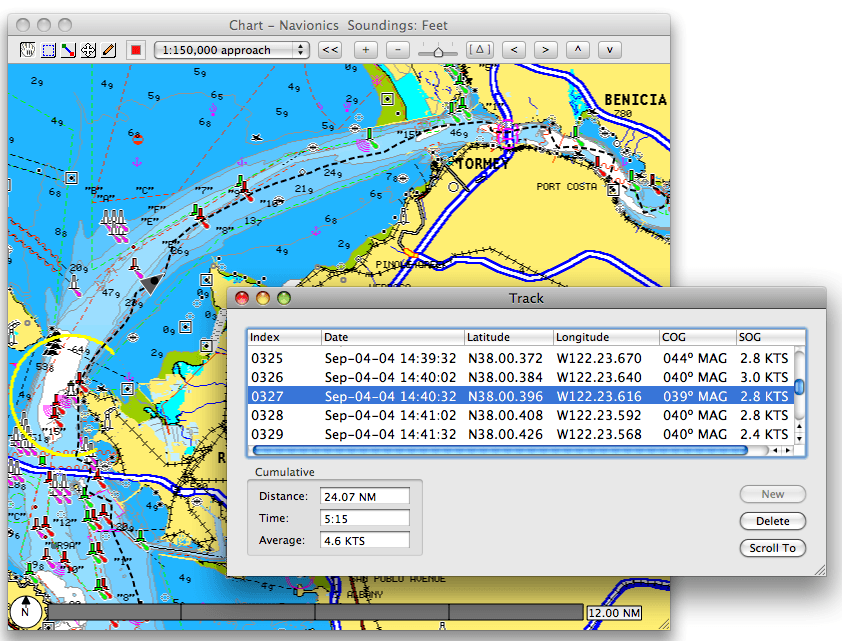
Track Logging – Log and plot historical position automatically at user selectable intervals including course, speed and instrument data. Track can be exported/imported and transferred from the GPS. See how efficiently you sailed your course. Use this information to implement changes in future routing.
Measure – Position, distance and bearing (true or magnetic) anywhere on the chart including great circle routing. This quick, easy, and accurate method of measurement makes paper chart measurement an antiquated methodology.
Built-in Alarms – Available for Anchor drag, Waypoint arrival, Cross Track error, Shallow water, and AIS/Radar vessel proximity. Both visual and audible cues are provided. User selectable range. Have you ever tried to sleep on the hook during foul weather, while wondering if your anchor was truly fast? Don’t depend on luck and guesswork. The integrated alarms add an additional level of comfort in knowing what’s really going on.
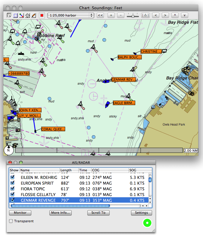
AIS/Radar – Automatic Identification System receiver displays local vessel traffic including name, call sign, length, speed, course, distance, destination and closest point of approach. RADAR shows tracked targets if sent over NMEA (not high def overlays). Both AIS and RADAR are plotted on the chart. AIS transponder can be used.
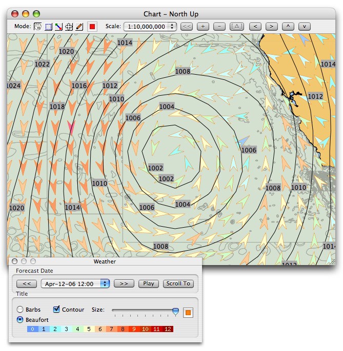
Weather – Using readily available and free GRIB weather forecast files, wind speed, wind direction, wave height, wave direction, current, pressure, precipitation rate, air and sea temperature are plotted on the chart. Choose the date and time of the forecast you wish to see. Knowing the forecast helps make key routing decisions.
In App help provides quick answers to most questions regarding configuration and use. Easy access to assistance will ensure that you quickly become a master of even the most complex program functions.
On-line app help docs available from the app and our web site too.
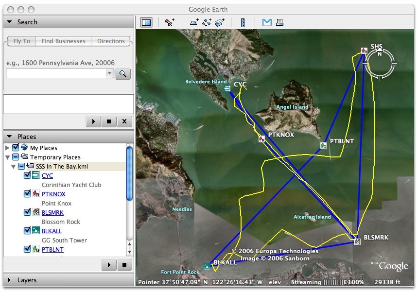
Google Earth Export – Plot waypoints, routes, tracks and weather in Google Earth. Friends and family can easily see your plans and progress with Google Earth on a Mac or PC.
TCP/IP Interface – Send and receive (TCP or UDP) NMEA data over wifi.
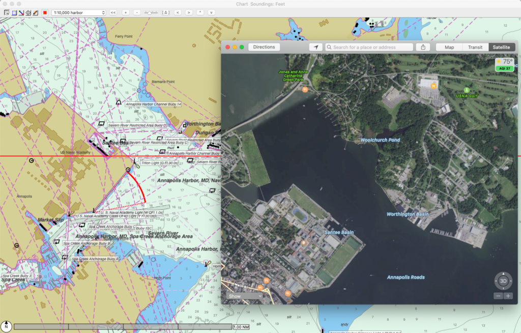
Apple Maps Integration – Control click on any chart location and launch Apple Maps straight there. See satellite views. See street views. Find that perfect destination, send to your phone, then hop in the dinghy and you’re ready to go!
Feature Highlights
HelmStation ChartStore
Cloud content and in-app automatics
HelmStation’s chart service combines our on-line ChartStore, our cloud-based account management, and MacENCx64 HelmStation Chart Account manager to provide an end-to-end automated marine chart provisioning experience.
We provide S-63 Encrypted, professional grade IHO Standard S-57 Vector ENCs delivered automatically to your Mac. Your purchased chart content is managed across your entitled devices with automated updates.
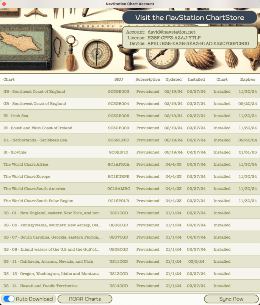
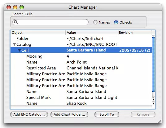
Chart Manager
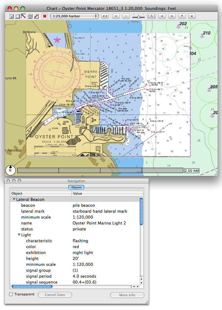
Displays list of available charts. Quickly scroll to any chart or any feature (navaid, facility or harbor). Manually add 3rd party chart content (ENCs & RNCs).
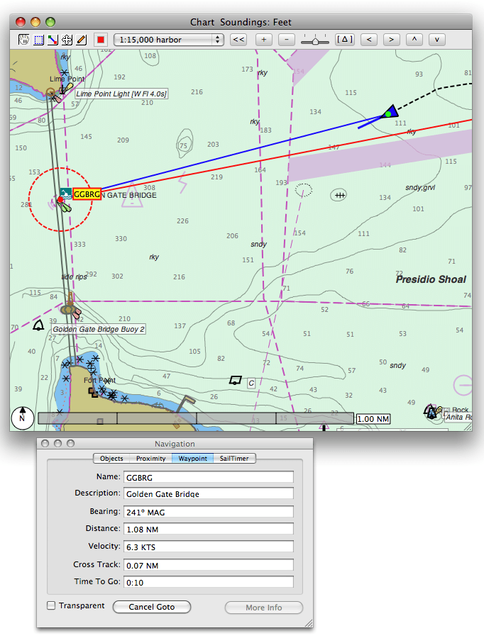
Chart Display and Navigation
In this window, the vessel is being navigated to the waypoint GGBRG (Golden Gate Bridge). The blue line shows the course to the active waypoint and the trailing dashed line shows the track history. In the Navigation Window, the distance and bearing to the active waypoint are shown.
MacENCx64
Free US NOAA ENCs
One-click selection of US Coast Guard District ENC Collections on live interactive map. Turn on/off selections at will. Automated download and installation.
Auto Updates
Keep safe with automated update of the latest charts.
GPS
Instruments
Displays realtime instruments data. Resizes and scales like the GPS Window.
Vector & Raster Chart Display
Display vector (ENC) and raster (RNC) charts. Clicking any navaid on the chart displays pertinent details in the Navigation Window.
charts.
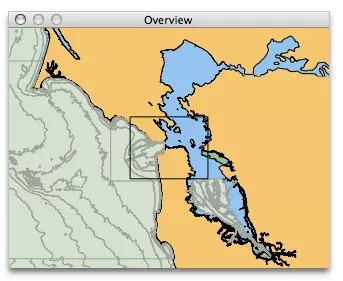
Overview
The Overview Window shows a zoomed out view. The box outlines what is shown in the Chart Window. The box can be grabbed to scroll the Chart Window.
Waypoints
Double clicking on the chart creates a new waypoint. Waypoints can be edited in place and saved and deleted and made active.
Routes
Routes can be created using waypoints. The selected route is plotted on the chart and the distance, bearing and time (cumulative and leg) are listed.
AIS & Radar
Connect a readily available AIS (Automatic Identification Receiver) or Radar to your Mac and “see” local vessel traffic.
Track
The historical position is stored. Selecting any row plots the past position on the chart including bearing and speed.
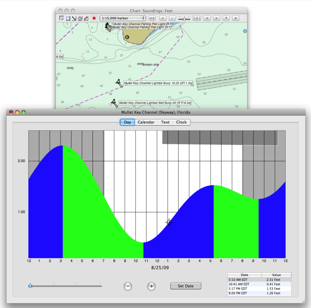
Tides & Currents
Click anywhere on the chart to get a tide or current graph via AyeTides.
Weather
Using readily available and free GRIB weather forecast files, wind speed, wind direction, pressure, air and sea temperature are plotted on the chart. Both traditional vectors with barbs or Beaufort scale filled vectors are available. Selecting the forecast is as easy as picking the date/time from the list.
Google Earth
Export waypoints, routes and tracks to Google Earth.
Apple Maps
Launch maps from any location on charts. See satellite views, get street views, find a great destination and send to your phone. Jump in the dinghy and go!